 Paint Creek TrailPaint Creek Trail
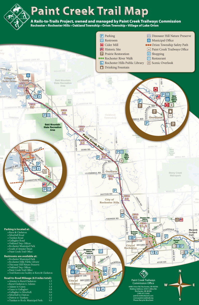
Connecting the communities of Rochester, Rochester Hills, Oakland Township, Orion Township and the Village of Lake Orion in Oakland County, Michigan.
The Paint Creek Trailways Commission provides Trail maps for our users and visitors to the area. For your convenience, you can download maps of the Paint Creek Trail, as well as other local Trail and park maps. For PDF maps, you will need Adobe Acrobat Reader. You can download it for free here.
For hard copies of most trail maps, contact the Paint Creek Trail office.
Paint Creek Trail |
Clinton River Trail |
Polly Ann Trail |
Oakland County Trail Network |
Color Map (PDF) Color Map (JPG)
Older Black and White Map (PDF) (224 KB) Older Black and White Map (JPG) (221 KB)
|
Color Clinton River Trail Page One (PDF) Color Clinton River Trail Page Two (PDF)
|
Color Map (PDF) (469 KB)
Polly Ann Trail - Lapeer Map (PDF) (420 KB)
|
Color Map (PDF) (New! Updated in 2010)
|
Macomb Orchard Trail |
Equestrian/Fishing |
Paint Creek to Polly Ann Temporary Route |
|
Color Macomb Orchard Trail Map Page One (PDF) (1.79 MB) Color Macomb Orchard Trail Map Page Two (PDF) (1.39 MB) |
Oakland County Equestrian Opportunity Map (PDF) Fishing along the Paint Creek Map (PDF) (1.74MB) |
Color Paint Creek to Polly Ann Route Map (PDF) (655 KB) |
|
Lake Orion Parking |
Michigan Regional Trail Sections |
Bald Mountain State Recreation Area |
Addison Oaks |
| Color Atwater Area Parking (PDF) (1.19 MB) |
Michigan Trail Sections Map (PDF) (628 KB) |
B/W Bald Mountain - South Unit Map (PDF) (33 KB) | Addison Oaks County Park Map (PDF) (457 KB) |
Paint Creek Trailways Commission, 4393 Collins Road, Rochester, Michigan 48306
Copyright ©2008-2012 Kristen Myers
All rights reserved